About RTOPO Hydrology
Simple, powerful and inexpensive CAD software for surveying. You can do triangulation, isolines, color-filled contour maps, sections, intersections, volume, simulation of rainwater runoff and editing XYZ files.
Simple, powerful and inexpensive CAD software for surveying. You can do triangulation, isolines, color-filled contour maps, sections, intersections, volume and much more. You can process hundreds of thousands of points or triangles, even on less powerful PCs.
Through its own CAD system (called RCAD), specialized for 3D and for a large number of entities, you can do:
-load and draw a file of points having the format: Number X Y Z Code; the drawing is made by POINT,3DPOLY,SPLINE or BLOCK entities, according to a modifiable library of codes
-edit interactively the XYZ files of points; you can modify the coordinates, the code and the position (in 3DPOLY or SPLINE)
-triangulate the points on a convex hull or between an external contour and possibly more interior contours
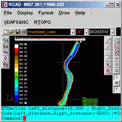
-contour lines and color-filled contour map
-cross sections and longitudinal profile
-the projection of several PLine entities over a triangulation
-simulation of rainwater runoff; identifies the watershed, the direction of the flow, the flooded areas, the speed and level of the water
-the conversion of a triangulation to a regular grid of points
-the conversion of the existing isolines resulting from maps in points and then in a triangulation
-represent the geological_stratification resulting from drilling
-calculate 3D area, center of gravity and the volume between 2 triangulations
-intersect and divide two triangulations or a triangulation by a horizontal plan
-interpolate a set of 3DFACE, using quartic triangular patches
-transform a drawing containing entities as PLine, Line, Block and Text, in XYZ points file
-represent 4D points cloud,
-import and export LandXML.
RCAD CAD system, distributed together with RTOPO, provides OpenGL real-time orbit, pan,zoom, shading, lighting and motion path animation. RCAD is similar with other popular CAD systems and can load and save DXF files. It has entries in the command text area, graphics area, menus and toolbars and can run scripts.
Previous Versions
Here you can find the changelog of RTOPO Hydrology since it was posted on our website on 2015-04-27 03:00:00.
The latest version is 3.4 and it was updated on 2024-03-27 20:53:24. See below the changes in each version.
RTOPO Hydrology version 3.4
Updated At: 2023-07-09
Changes: It can simulate rainwater runoff.
RTOPO Hydrology version 3.3
Updated At: 2022-12-14
Changes: It can be purchased with a 1-year subscription.
RTOPO Hydrology version 3.3
Updated At: 2017-10-22
Changes: Discount price
RTOPO Hydrology version 3.3s
Updated At: 2017-08-25
Changes: It can also be purchased with 4 month subscription
RTOPO Hydrology version 3.3
Updated At: 2017-04-25
Changes: Import and export of LandXML files type. The price is for a 4 month subscription.
RTOPO Hydrology version 3.3
Updated At: 2017-04-25
Changes: Import and export of LandXML files type.
RTOPO Hydrology version 3.2
Updated At: 2015-09-21
Changes: 50% price discount until August 31, 2016!
OpenGL Performance Optimization.
RTOPO Hydrology version 1.9
Updated At: 2009-01-05
Changes: Can interpret 3DMESH entities from DXF files.
Disclaimer
External Download
We do not host RTOPO Hydrology on our servers. We did not scan it for viruses, adware, spyware or other type of malware. This app is hosted by the software publisher and passed their terms and conditions to be listed there. We recommend caution when installing it.
The external download link for RTOPO Hydrology is provided to you by apps112.com without any warranties, representations or guarantees of any kind, so access it at your own risk.
If you have questions regarding this particular app contact the publisher directly. For questions about the functionalities of apps112.com contact us.